Rocks Tell the Tale
Geologists Brave Cold and Long Hours to Study Plate Tectonics in Alaska
January 19, 2010
By Russ L. Hudson

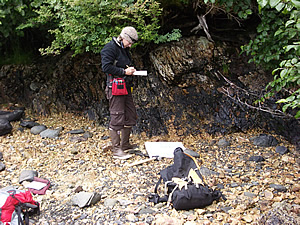
Jenny Arkle records rocks samples just south of Contact Fault on Cow Pens Island. The rocks may provide significant information on the tectonic history of the area.
Conducting geologic research is different in Alaska’s Prince William Sound.
It is science without the lab coat but plenty of grit, and that's what Phillip A. Armstrong, Cal State Fullerton geologist, teaches select students by taking them on his research trips.
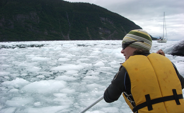
Jenny Arkle, a graduate geology major and one-time Grand Canyon river-raft guide when she joined Armstrong's research team in 2008, came to the project already a seasoned outdoorswoman, but she was surprised by the differences from the Grand Canyon. “I was rowing through chunks of ice to get some samples from a glacier in the Sound when an 800-pound bull Stellar sea lion saw us as intruders and came after us. I rowed away fast and we went around an island before we got our samples.”
Once at the glacier, getting samples of the rock washed out by melt water wasn’t easy, said Jade Brush, a senior geological sciences major who went to the Sound last July. “Dr. Armstrong demonstrated gold-panning techniques to sift for samples using our frying pans. Later, we had to clean out the same pans so we could cook dinner. My neoprene boots were my best friend. They kept my feet from freezing in the icy water.”
Armstrong’s students also learn to cope with cold, calving glaciers and 14-hour workdays mapping deformations in the Earth’s crust, such as the domes, ridges and faults caused by the collision of the Pacific and North American tectonic plates at the Sound.

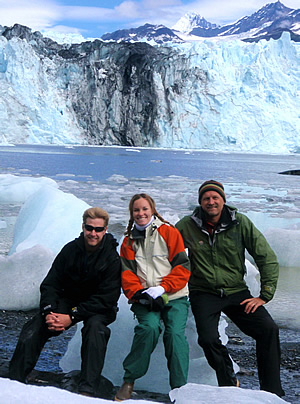
Michael Prior, left, Jade Brush and Phil Armstrong take a break, relaxing on a chunk of glacial ice.
Lab work
Back at Cal State Fullerton, they go into the lab to assess the data they brought back from Alaska. Senior geology major Kassandra Sendziak landed on glacial gravel in a two-seater airplane during a 2008 trip and hiked hours through rugged, unmarked territory to collect her data, only to log more hours in a campus lab to finish the process.
“The lab work took months, from processing the samples, concentrating on the zircon (which contains tiny amounts of uranium that can be used to check the age of the sample) to measuring its rate of radioactive decay. Interpreting the data is the exciting part that makes all the tedious lab work worth it!
“The combination of field research and lab work taught me patience and, intimately, the process of trial and error, and the importance of creativity, experimentation and the difference between science in the classroom and science in the real world of research,” Sendziak explains. “The only thing that can truly prepare you for research, is research.”
Armstrong’s investigation in Prince William Sound is funded for two more years by a $149,000 grant from the American Chemical Society-Petroleum Research Fund. ACS members know the associate professor of geological sciences as an expert in plate tectonics and uplift. The grant calls for him to map the deformations around the 13,000-foot-high Chugach Mountains that rise straight out of the Sound.
Although deformations are potential collection points for petroleum and natural gas, Armstrong is quick to point out that there is no petroleum exploration in Prince William Sound, a pristine wilderness, “but the forces that formed the Chugach could cause deformations in the Earth’s crust hundreds of miles away, and our mapping will provide a model. Knowing likely places to drill can save petroleum explorers millions of dollars.”
Ages of rock
Where to map is determined by the rocks’ ages. Rock on one side of a fault, ridge or dome rises faster than the other side, as shown by the rate of decay. Likewise, rock at the top or one side of a mountain is older than the other. Glaciers crush the rock as they move downhill then wash it out the bottom with melt water, bringing the samples to Armstrong and his students.
“If the rocks indicate the likelihood that something needs mapping, we might charter a helicopter to get to the source of the rocks,” Armstrong explains. Or, often, they simply hike in.
To accompany him on this rugged work, Armstrong chooses research students based on grounding in geological science, physical hardiness, familiarity with camping and adventurousness.
Armstrong’s interest isn’t exactly the same as ACS’s, but the study of the area is still done the same way, by looking at the ages of rocks. His passion pushes him to pursue the research, in spite of its rigors, and he wants to ignite that enthusiasm in others. He voices it simply: “Whenever I look at a mountain, I can’t help wondering how it got there.” That wondering has led him and his students all over the U.S., as well as to Mexico and New Zealand, and resulted in more than 60 papers.

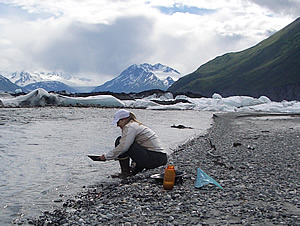
Kassandra Sendziak pans for minerals.
'That's the fun'
Armstrong takes his work seriously, as his awards and publications attest, but it isn’t just work to him. “Finding out how the mountains behave, well, that’s the fun. I hope to keep getting grants to do this.”
The geologist has influenced at least one student who shares his passion for knowing how things got that way. Michael Prior, a senior who joined Armstrong in Prince William Sound last July, said, “When I was young, I wanted to understand the things I saw while camping. Geology was a way to do that, so I majored in it. When I heard Dr. Armstrong was going to the Chugach, I jumped at it, and the first-hand experience was great. Now I plan to get a master’s in geology and I want to be well-rounded in fieldwork, as well as lab work.”
A member of the faculty since 1999, Armstrong earned his doctorate in geophysics and his master's in geology from the University of Utah in Salt Lake City. He has conducted research worldwide.


