

Space Sense
New lab blasts in to CSUF, opens universe of opportunities for researchers and students
May 1, 2007
By Mimi Ko Cruz
It was a violent and stormy day in the summer of 2005 when Hurricane Katrina slammed New Orleans, causing death and destruction so devastating that residents still are recovering from it and scientists still are studying it.
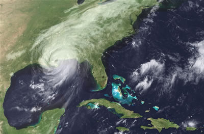
Hurricane Katrina
- photo courtesy GOES
Project Science Office
If there is any benefit, at least to researchers, it is that the
relief efforts were significantly aided by satellite imagery.
Starting this fall, remote sensing, the use of satellites to gather data
and images to study the earth or other bodies of the solar system, will be
available at Cal State Fullerton.
With a $696,735 NASA (National Aeronautics and Space Administration) grant,
CSUF is building and equipping a remote sensing laboratory on the fourth
floor of the Humanities and Social Sciences building.
The 969-square-foot Center for Remote Sensing, will feature 15 workstations
with double monitor computers, special lighting, lecture space and a research
area. Expected to open in the fall, it will house the technology used to
survey, observe and measure the Earth’s surface and atmosphere, the
planets and the entire universe.
“We are extremely excited to be creating this new center that will
benefit generations of students,” said Thomas P. Klammer, dean of the
College of Humanities and Social Sciences. “Remote sensing is a critically
important tool in regional planning and environmental monitoring and research,
but it has a wide and expanding variety of applications. The Center for Remote
Sensing will offer new opportunities to students in environmental studies,
geography and a variety of other fields.
Its uses are important to local companies as well as to the state and
federal government.”
Remote sensing is “a very powerful tool,” added Robert Voeks,
professor of geography and the center’s director. “It’s
relatively user-friendly and we can do a lot of work with the images from
satellites, looking at things like environmental challenges and global warming,
for example.”
Voeks, who researches the effects of population growth and deforestation
in Brazil, said remote sensing will allow him to make analysis on a larger
scale.
“It allows us to really look at the big picture,” he said. “It
is going to change the way I do research.”
In the past, Voeks explained, he examined vegetation change in tropical
forests in Brazil and northern Borneo with air photos and simple plant transects
in the field. Those methods are, however, time-consuming and limited to relatively
small areas. The use of satellite imagery will permit region-wide analysis
of forest loss due to factors such as cattle ranching, plantation expansion,
and destructive forestry practices.
With satellite images, “we look for changes in the thermal signature
of land or water surfaces,” Voeks said. “This tells us, for example,
if old-growth forest is healthy or diseased, if primary forest is being replaced
by second growth and if invasive species are making inroads into protected
areas. We can measure carbon balance of vegetation on a broad scale, which
is an important dimension of global climate change. The list of possible
research applications is pretty endless.”
Most importantly, he said, “we’ll be able to measure change through
time because we can superimpose images from today with ones taken decades
ago.”
Jonathan S. Taylor, associate professor of geography and the new center’s
associate director, said remote sensing also will be useful in his research
of land use and land cover change.
He said his research on environmental change in Okinawa, Japan will be
greatly enhanced by satellite imagery.
“I’ve never had this quality of remote sensing capabilities before,” Taylor
said. “It will allow me to quantify things that before I had to study
more qualitatively.”
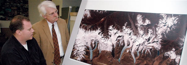
He said there are plans to use the new lab to study the melting glaciers
in the Himalayas and coral reef degradation in the Pacific and Caribbean.
“What we’ll be looking for is change,” Taylor said. “With
coral reefs, for example, we can use satellite images to analyze the health
of the reef and see what percentage of the reef is dead. With glaciers, we
will be able to see and quantitatively measure how much they’ve melted.
“Global warming is becoming an increasingly important topic of discussion
and our new lab gives Cal State Fullerton a very good technical facility
to analyze problems that global warming might be causing,” he added.
And, remote sensing will play a big role, Voeks, Taylor and Klammer agreed.
Remote sensing has far-reaching applications. For example, satellite images
helped determine the extent of the destruction to the World Trade Center
after 9/11. The pictures also monitor potential damage to the Space Shuttle
in orbit.
“Students who have had fun playing with Google Earth on their computers
are about to discover that they can now specialize in the technology that
made the wonders of Google Earth possible,” Klammer said.
Students will be offered four courses involving remote sensing and research
in the new lab that will concentrate on monitoring and analyzing environmental
problems such as air quality, wetlands and coastal zone management, geological
hazard mapping, environmental risk assessment, land use planning, urbanization,
vegetation change, water quality mapping, soil erosion assessment, wildlife
habitat protection and homeland security.
“Our research and instruction will directly support NASA’s commitment
to better understand and protect our home planet for the benefit of all humanity,” Voeks
said.
Undergraduate students will gain knowledge and experience in geospatial
analysis and preparation for employment in the environmental field through
the soon-to-open center, he said. And, graduate students will master remote
sensing technology and increase their chances of entering prestigious doctoral
programs.