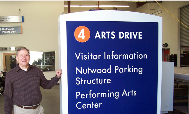
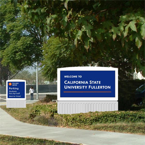
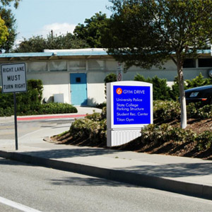
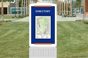
 Caption: Charles Holt, field manager for Parking and Transportation Services, stands beside one of the directional signs slated for installation on campus this summer. Photos courtesy of the Office of Design and ConstructionDownload Photo
University Initiative
The Signs — They Are a Changin’
New Signage Being Installed Throughout Campus
Getting into and around campus will soon be a lot easier, thanks to the university's ambitious new signage project.
“It’s definitely time to replace the current signs, some of which have been in place for at least 20 years,” said Jay Bond, associate vice president of facilities management. “They are outdated, faded, inaccurate, unhelpful and present an image to the community that is the complete opposite of the quality institution we are.
“The new signs will aid in visitors and campus members in finding their way around the campus. We also wanted signs that would be welcoming and friendly to visitors and newcomers to Cal State Fullerton.”
Last April, the Academic Senate approved a resolution recommending the implementation of a comprehensive, campuswide signage program to provide better guidance and visually unify the campus. The program falls under Titan Pride, one of the university's strategic initiatives.
The Titan Pride initiative will showcase academic and athletic success, ensure that physical facilities are a positive reflection of CSUF’s institutional quality, and forge stronger integration with the community beyond campus.
Preliminary work has been completed to prepare for perimeter signage, says Jack Bage, associate director of the Office of Design and Construction. Directional signs identifying each entrance and major destinations that can be reached from those entrances will be placed at the university’s 10 entrances, including Arts and Gymnasium drives.
Fluted white bases for the entrance road signs were installed the week of July 5. Later this month, new monument signs welcoming visitors and members of the campus community will be installed at Folino Drive and Nutwood Avenue, and at Associated Road and Yorba Linda Boulevard.
Welcome to Cal State Fullerton
Once onto campus, secondary directional signs will feature arrows to campus destinations, such as housing or a certain parking structure. Signs at the entrance to campus parking lots will identify each lot, the permits required to park there and other restrictions, such as disabled persons parking only, said Bage.
The welcome or monument signs and the primary directional signs will be internally illuminated; the secondary directional signs will have applied reflective vinyl lettering, Bage explained.
“These signs will help drivers enter the appropriate entrances to reach the location they are seeking,” said Tom Grayson, project manager in design and construction. “They also will provide additional information that we previously didn’t have on campus signage.”
Pedestrian Directions
Throughout the campus pedestrian signs will be posted with campus maps and directories to further help campus visitors.
“The current phase includes four or five of these signs along Folino and East Campus Drive around the Eastside Parking Structure as a sample of what will be added later,” said Bage. “A pedestrian way-finding directory with a ‘You-R-Here’ map of the campus will be posted at key pedestrian walking areas, such as the walkway on the west side of the Eastside Parking to direct people to campus buildings after they have parked their vehicles.
Around student housing, similar signs will carry both campus and residential area maps.
Signage to Help Find Parking
In a separate but related project, signs are being installed adjacent to the Nutwood and State College Parking Structures that identify how many spaces are available in each structure, as well as the number of available parking spaces in the university’s other parking structures. They will be similar to the ones located on the north and south sides of the Eastside Parking Structure. Those will be replaced with new ones that carry information for the other parking structures, said Bage.
“So, a commuter exiting the 57 freeway on Nutwood Avenue and driving towards campus will be able to see how many parking spaces are available in each structure and make a decision where to park based on space availability,” said Joe Ferrer, director of parking and transportation. “In addition, we're looking into developing a mobile application to access space count info via a PDA, such an iPhone.
“We are also looking into incorporating the space count info into a layer of the interactive campus map being developed for geographic information systems, or GIS,” Ferrer added. “This layer will allow visitors to view a campus map through the homepage and see the same space count info.”
“The benefits of these combined projects will be enjoyed by the campus community for years to come,” said Charles Holt, field manager for Parking and Transportation Services.
July 12, 2011


